Monday, September 28, 2009

New Hampshire Fall Foliage - Parting Shots

After a full day of rain yesterday, today was warm and mostly clear. The full fall foliage is not yet here. To find good color takes some searching but it can be found. The Kancamagus Highway gave me a good selection.


I wish I had planned a few more days here, but it is time to move on to Ausable, NY tomorrow morning.

Sunday, September 27, 2009

Franconia Notch

Most of the hikes here would push me too hard but I found one that works for me. The Falling Water Trail climbs up the easterly side of the Gorge, following two small streams.


There were too many trees to catch any views across the gorge but that was OK. It was a delightful hike.


Mount Washington, NH

On the 24th, wearing shorts and tee shirt, I left Millinocket and drove to Franconia, NH in the midst of the White Mountains. Pretty impressive, I would say. The weather was nice when I pulled in, but my campsite was very uneven. I needed blocks under all 4 hydraulic lifts to manage to get Enterprise level.

There is almost no TV reception, and I need the signal booster for internet and cell phone access.

I caught a weather forecast. Sunny skies and moderate temperatures are forecast for Friday and Saturday, then rain for 3 days. I planned to get to Mount Washington early to take advantage of the good weather. After all, Mount Washington is said to have the worst weather on earth. The fastest winds ever measured were there, 240 mph or 408 KPH. The winter temperature often drops to -40 (-40C). Three feet below the surface the ground is permanently frozen.

Friday morning, the sky was mostly overcast, with occasional patches of blue. I decided to go for it. Nearing the Mt. Washington Cog Railway, the lower part of the mountain was clear, but the upper part was shrouded in the clouds. I noticed a wisp of steam from the steam engine climbing the cog railway as I approached.


At the railway station, it was partly cloudy, a light breeze, and temperature of about 60 to 65 (18C). The weather report for the top was 20 (-7C) with a 50 mph wind (83 KPH) for a wind chill factor of -6 (-21C). Visibility was 100 feet.

The train took us up into the clouds.

Soon, we were seeing frost on the vegetation. Not long after that, there was no vegetation that we could see.


Looking carefully at the top, some lichens and mosses could be found among the rocks. Mostly, it was just broken rock coated with ice. The combination of wind and cold and damp formed streamers of rime or hoarfrost on all surfaces.


After dutifully standing at the top, the highest point in the northeastern US,
it was time to start down. It was an interesting sensation to be in the clouds one moment, then peeking below them the next.

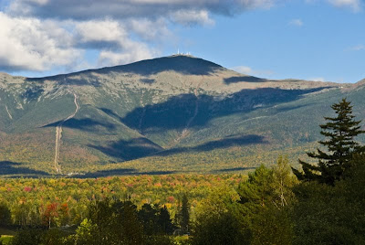
Driving away, the day was beautiful. These shots are taken on the slopes of Mt Washington, within 1 hour of standing on the summit in the fog and ice.


The view back toward Mount Washington showed the top wrapped in... sunshine.

Clearly, the weather had outfoxed me.

I had the feeling that I was being laughed at.

Wednesday, September 23, 2009

Thank you, Millinocket

It is time to leave. The leaves are changing fast, and I am due in Franconia Notch.


Some thank you's are in order, and this seems to be a good time and place for that.
- To Dawn, the first person to greet me and make me feel welcome in Millinocket, and to the rest of the folks at the Appalachian Trail Cafe, for steadfastly maintaining that sense of welcome.
- To Gail, who showed me how to make and use a moose call. She didn't understand why the idea of luring an amorous moose to me might not be appealing, but she was a fount of knowledge of the area, telling me about good photo locations, roads and trails.
- To Charlie, who showed me the way to Sandy Stream Pond and showed me my first Maine moose.
- To Ranger Cathy, for her enthusiastic discussions, whether I was entering or leaving the Park.
- To Ranger Bill, for listening to my needs and constraints and for helping me find hikes within my capabilities.
- Finally, for the gentleman (I forgot his name) whom I met on the trail today and whom I teased about his Santa beard. He was so filled with joy and love of this place, its creatures, and the people who come here to absorb and enjoy this place.


Thank you, Millinocket.

Tuesday, September 22, 2009

Fall Foliage

It is coming on fast!


So far, I mostly see reds. It seems that they are much more red than I am used to seeing. This could be really nice soon...

Saturday, September 19, 2009

The Start of the Leaf Change

It is starting.


If you compare the earlier shots of Sandy Stream Pond with a shot from 2 days ago, they are starting to change from green to a paler tone.


Today, the colors are becoming more dramatic.


The grass in the bogs is almost yellow.


Finally, a moose from two days ago


and from today.


The moose seem to be just as dark.

Friday, September 18, 2009

The Through Hiker

In late winter or early spring, a number of backpackers embark on a quest from Springer Mountain, GA. Their objective is the top of Mount Katahdin, ME which, if successful, they will reach in the fall before snow and ice on its granite slopes close access to the upper reaches of this northernmost point on the Appalachian Trail. Like so many, I have hiked portions of The Trail, in many states. About 13 or 14 years ago, I managed 14 miles in Virginia with a full pack. That is the longest section of trail I have done in one shot.

The AT has been described as "A Walk In The Woods", to quote the title of a very enjoyable title of a book about one person's experiences on the AT. That fits all of my experiences on the AT.

I want to quantify the tremendous effort involved in through hiking (hiking the full length of the AT in one season). I find myself able to hike about 1.5 miles, after which I need a day of rest. Setting aside the issues of re-provisioning and water supply (as the AT follows crests, there is little water available except at shelter areas), at a rate of 1.5 miles every other day, it would take me 14.4 YEARS to traverse the AT, assuming that I had 200 days per year to hike, and taking no time off for rainy weather.

And yet, so many have completed this quest in one season.

I saw my first through hiker about 10 days ago. It occurred to me that a picture of him walking along, worn boots dangling from his pack, in light sandals on this very easy and level part of the trail, with Elbow Pond to his left and birch and conifers to his right would be a nice composition. I immediately began to follow him as I took my lens cap off.

By the time I had gone about 50 paces, he was out of sight.

I did not get my picture, but the image remains in my mind.

So, this post is, simply, a tribute to those who are known as the Through Hikers. I finish with a few photos representative of the AT that I have not yet posted.


Tuesday, September 8, 2009

Moose!

On my first four hikes to Sandy Stream Pond, I saw moose four times. Most of the sightings were on the far side of the pond, really out of reach of my lens. I was also seeing Loons (a family of Mama, Papa and baby), deer and geese, all too far away to photo. I had a bigger telephoto but it was too heavy for me to pack it in. I sold that lens and used the money to buy a 500mm reflex (mirror) lens. Since then, until yesterday, I saw no more critters of any kind. When I asked at the gate, nobody was seeing moose anywhere. All because I bought a lens?

Well, yesterday there was a moose at Sandy Stream pond. I got there late in the afternoon. The light was not very good. It was setting behind the moose, but I was able to get a few shots.


The moose was not alone.

Leaving the park, it was well past sunset but when I got to Togue Pond, I was surprised to find the sky still luminous after sunset.

What a great finish to the day!