Sunday, May 26, 2013
Spring Has Sprung in the Tetons
In one week the primary tones have changed from grey to green. Life sprouts anew.
Beavers are out and about, feeding on new sprouts.
A hike up the hill across the road from the campground yields colorful scenes.
Jigsaw Puzzle, anyone?
Wednesday, May 15, 2013
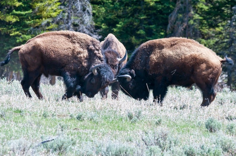
Boys will be boys
It is spring in the Tetons, and bisons' thoughts turn to... dominance. This will be mostly photos. I will say only that these critters were in the field between the campground and the road, and I did NOT get out of the car.
I don't know quite how I got motion from that. Anyway, here are the rest.
I have 50 shots of the competition, but that is enough for sharing.
I don't know quite how I got motion from that. Anyway, here are the rest.
I have 50 shots of the competition, but that is enough for sharing.
Friday, May 10, 2013
Back to Winter - almost
I made it to the Tetons. In New Mexico, when I left in late March I was doing my hikes in shorts and a T-shirt, and sometimes just shorts. From there, I went to southern California, then up the eastern side of the Sierras, in warm, sunny weather all the way.
When I got home to Oregon, the weather gave me my second taste of snow with a brief flurry that sugar-coated the trees. The Cascades were sleeping under a white blanket but elsewhere, it looked like late spring.
Here in Wyoming, I am struggling to find manageable hikes. I tried two yesterday, turning around within 900 feet on each because of snow cover. No matter - the views are my main reason to be here.
From the main road overlooking the Snake River, the Tetons rise from a flat plain. The abrupt change from prairie to peaks is the foundation for the scenery.
Located just south of Yellowstone, the Tetons share most of the wildlife found in the larger park to the north. So far, I am seeing bison every day.
How does a bison scratch its nose? Well, you find a log, then go for it.
Three days ago, the late afternoon skies became threatening. At one point, the dark clouds provided a stunning backdrop for the sage and trees painted silver-white by the sun peeking through a break in the cloud cover.
The next morning, I arose at sunrise long enough for a quick shot from my campsite of the morning sun painting the peaks.
Colter Bay at the north end of the park is set on Jackson Lake. It is still frozen, but a narrow stretch of water between the shore and the ice, on a still afternoon, made a delightful mirror.
When I got home to Oregon, the weather gave me my second taste of snow with a brief flurry that sugar-coated the trees. The Cascades were sleeping under a white blanket but elsewhere, it looked like late spring.
Here in Wyoming, I am struggling to find manageable hikes. I tried two yesterday, turning around within 900 feet on each because of snow cover. No matter - the views are my main reason to be here.
From the main road overlooking the Snake River, the Tetons rise from a flat plain. The abrupt change from prairie to peaks is the foundation for the scenery.
Located just south of Yellowstone, the Tetons share most of the wildlife found in the larger park to the north. So far, I am seeing bison every day.
How does a bison scratch its nose? Well, you find a log, then go for it.
Three days ago, the late afternoon skies became threatening. At one point, the dark clouds provided a stunning backdrop for the sage and trees painted silver-white by the sun peeking through a break in the cloud cover.
The next morning, I arose at sunrise long enough for a quick shot from my campsite of the morning sun painting the peaks.
Colter Bay at the north end of the park is set on Jackson Lake. It is still frozen, but a narrow stretch of water between the shore and the ice, on a still afternoon, made a delightful mirror.
Now, as soon as enough snow melts from the trails, I will get more hiking in...
Sunday, May 5, 2013
Travelin' Time
I got an 'atta boy from my doctor, leaving me free to "phone in" my fall appointment. That means I am able to return to Colorado this summer to spend some relaxing time there rather than driving through, tense as a drum, with a malfunctioning towed car braking system, like last summer. I planned my departure and left home, heading for the Tetons as my first destination.
The Tetons are a three day drive from home. My second night on the road, I stayed at a city park in Burley, Idaho, at the side of the Snake River. The cloudy afternoon through which I had been driving evolved into a break in the clouds at just the right place and moment.
While the subtle lighting of the higher clouds was interesting, the real gem was the steel truss bridge so nicely silhouetted in the setting sun.
The next day was wet, grey and cold. The Snake River and I climbed to above 7000 feet elevation to reach the Grand Tetons. I have seen them in late June with my family in 1963, in late September in 2011, and in July and August, 2012. Entering the Park with a sense of anticipation, I saw... nothing. Clouds obscured all but the very bottoms of the peaks.
I checked into the campgrounds and set up, planning a 2 month stay with no hookups.
The next morning dawned clear and crisp. Tent campers on the neighboring site were taking photos of... the bare trees? It made no sense but looking where they were pointing their cameras, that was all I saw. Then a shape emerged from behind several trees.
It is good to be back here.
The Tetons are a three day drive from home. My second night on the road, I stayed at a city park in Burley, Idaho, at the side of the Snake River. The cloudy afternoon through which I had been driving evolved into a break in the clouds at just the right place and moment.
While the subtle lighting of the higher clouds was interesting, the real gem was the steel truss bridge so nicely silhouetted in the setting sun.
The next day was wet, grey and cold. The Snake River and I climbed to above 7000 feet elevation to reach the Grand Tetons. I have seen them in late June with my family in 1963, in late September in 2011, and in July and August, 2012. Entering the Park with a sense of anticipation, I saw... nothing. Clouds obscured all but the very bottoms of the peaks.
I checked into the campgrounds and set up, planning a 2 month stay with no hookups.
The next morning dawned clear and crisp. Tent campers on the neighboring site were taking photos of... the bare trees? It made no sense but looking where they were pointing their cameras, that was all I saw. Then a shape emerged from behind several trees.
It is good to be back here.
Saturday, April 13, 2013
Whitney
Wow.
On the way north, I planned a stop in the area of Mt. Whitney, the highest peak in the lower 48. It is 14,505 feet high, is on the eastern edge of the Sierra Nevada range, directly east of Sequoia National Park. This means it is made of the same medium grey granite that forms the bulk of the Sierras.
What is different is that the peaks here are unprotected by foothills. They rise directly from the desert around Lone Pine, CA.
My first day full day here, I drove a road known as Whitney Portal Road. On the flats just west of Lone Pine, some great views of the Whitney massif can be seen.
I was ready to stretch my legs, so at the Portal, 8400 feet up, I took a short hike along the Whitney Trail. I would love to have reached one of the lakes, but they were out of my range. I had to settle for this.
That evening, the peaks blocked the sunset, but I had a hint of what it might have looked like.
I got up before dawn the next morning and set up my tripod, waiting for the light. Some cloud cover to the east blocked some of the color but it still was nice when the sun found a hole through which to peek.
The morning after that, there were no clouds. The first few seconds of direct light on the peaks were rich with reds.
Moments after, the color muted to orange, then yellow-orange.
Not too shabby a way to wake up.
On the way north, I planned a stop in the area of Mt. Whitney, the highest peak in the lower 48. It is 14,505 feet high, is on the eastern edge of the Sierra Nevada range, directly east of Sequoia National Park. This means it is made of the same medium grey granite that forms the bulk of the Sierras.
What is different is that the peaks here are unprotected by foothills. They rise directly from the desert around Lone Pine, CA.
My first day full day here, I drove a road known as Whitney Portal Road. On the flats just west of Lone Pine, some great views of the Whitney massif can be seen.
I was ready to stretch my legs, so at the Portal, 8400 feet up, I took a short hike along the Whitney Trail. I would love to have reached one of the lakes, but they were out of my range. I had to settle for this.
That evening, the peaks blocked the sunset, but I had a hint of what it might have looked like.
I got up before dawn the next morning and set up my tripod, waiting for the light. Some cloud cover to the east blocked some of the color but it still was nice when the sun found a hole through which to peek.
The morning after that, there were no clouds. The first few seconds of direct light on the peaks were rich with reds.
Moments after, the color muted to orange, then yellow-orange.
Not too shabby a way to wake up.
Sunday, April 7, 2013
...and now for something completely different,
... to quote John Cleese, of Monty Python...
A very simple description of most of my postings might be "What Hath God Wrought". Few of my posts are about people and focus much more on nature.
Well, not this time. I traveled to southern California, to meet friends from Florida. Their daughter was part of a national soccer tournament, and they flew to the San Diego area to watch her play. I traveled a few days out of my way enroute home to Oregon to meet them.
My first day, I took a hike while waiting for them to arrive. Three days sitting in the seat of Enterprise was enough. I needed to move a bit. The Mission Hills trail system was nearby, and I hungered for running water, so off I went.
The San Diego River didn't look like much of a river this far up, but it provided a pretty setting after 5 months in the desert.
The next day, the three of us went for a hike in the Torrey Pines area.
The trails are set on a bluff overlooking the beach, with eroded terrain providing the views.
The next day, the soccer tournament began. We were 10 feet from the sideline, mid-field. The athletes were skilled and competitive, just what you would expect from players at this level.
Thanks, guys. Good to see you again.
A very simple description of most of my postings might be "What Hath God Wrought". Few of my posts are about people and focus much more on nature.
Well, not this time. I traveled to southern California, to meet friends from Florida. Their daughter was part of a national soccer tournament, and they flew to the San Diego area to watch her play. I traveled a few days out of my way enroute home to Oregon to meet them.
My first day, I took a hike while waiting for them to arrive. Three days sitting in the seat of Enterprise was enough. I needed to move a bit. The Mission Hills trail system was nearby, and I hungered for running water, so off I went.
The San Diego River didn't look like much of a river this far up, but it provided a pretty setting after 5 months in the desert.
The next day, the three of us went for a hike in the Torrey Pines area.
The trails are set on a bluff overlooking the beach, with eroded terrain providing the views.
The next day, the soccer tournament began. We were 10 feet from the sideline, mid-field. The athletes were skilled and competitive, just what you would expect from players at this level.
Thanks, guys. Good to see you again.
Subscribe to:
Posts (Atom)