Sunday, May 24, 2009

The Youghiogheny River

The Youghiogheny River in Ohiopyle State Park in southwestern PA is one of the foremost white water rivers in the east. Known as the Yough (rhymes with sock) has 3 sections. The upper and middle are milder with Class I and II runs. The lower Yough has Class III and IV, depending on river levels. They are separated by the Ohiopyle Falls, a 25' drop on the main channel.


A beautiful trail system exists in the area. They are a mix of foot trails like the Ferncliff Trail
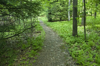
and bike or foot trails like the Youghiogheny River Trail which, by one name or another, connects a bike trail from Pittsburgh to Washington.

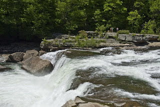
The trails give access to scenes like this small waterfall on the Youghiogheny River trail


and to Cucumber Falls.


The trails are gems, but I have one criticism. The main gem of the Ohiopyle State Park area is the rapids on the Yough. Except for the put-in and take-out points, the river is all but inaccessible. With a little bit of planning, design and effort, some rough trails could be made that would allow access to the runs. One such has been made by repeated use. It takes some effort and a LOT of care, but is worth it (even if getting there and back DID put me back on tylenol).

Surf's up, dude!
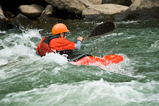


These rafters said the river was so easy that they could paddle it using just one hand!
Sometimes I wonder about people...

If you want to get wet but don't want to paddle the river, there is always the Sliding Rock area. In North Carolina, the Sliding Rock area was wide and mostly a thin film of water over the rocks. Here, the stream has worn a channel into the rocks and is a LOT faster than in NC.
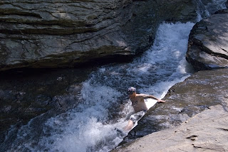

The lower end of the sliding area finishes with a shallow pool, then a small waterfall into a deeper pool.

Tuesday, May 19, 2009

Summersville Lake

I have been staying at Battle Run on the Summersville Reservoir. This reservoir is formed by a dam on the Gauley River that was built in the '60's. I am told that it was dedicated by Lady Byrd Johnson. The dam was finished before a small mountain hamlet that was to be submerged, named God, was vacated and removed. It seems that Lady Byrd refused to name the dam for the town it was displacing, saying that there was no way she would dedicate a structure with the name "God Dam". The name was changed to that of the nearest town to remain, Summersville.


Yesterday morning I awoke to low fog over the water formed by the cold night air meeting the warmer surface waters. As the sun rose I saw some spectacular scenes formed by the mist, the rising sun and the trees at my campsite. These shots were all taken within 5 feet of the door of Enterprise.


Sandstone Falls

Yesterday I drove south to Sandstone Falls. At this spot, the New River flows over a hard sandstone underlaid by softer shales. The shales erode away, then the sandstone layer breaks off, forming the falls.

There are two sets of falls. The lower, or westerly falls are spread over a fairly wide drop edge and are preceded by a number of smaller drops resulting in a drop of about 10 feet at the end. They are very accessible by a wooden walkway that leads to various vantage points along and below the drop.


This was a popular fishing spot. One angler, either very lucky or very skillful had a catch of about 20 fish ranging up to smallmouth bass about 14" long.


To the east a bit is the main or upper falls. These have a much smaller drop edge, much more volume, and a 25' drop. Unfortunately, I could not get to them to photograph them except from an overlook high on the east bank. That vantage point was good for looking at them, but not for pics.

Saturday, May 16, 2009

Down By The River...

Today I got down to the river to watch the running of the rapids. (wait for the video to load)


My descent began on the east side of the gorge, where the old road to the old bridge joins the new road crossing the new bridge.


Once down at the river's edge, I had a great view of the rafters, the kayakers... and the swimmers.


Yep - there are two guys SWIMMING that run!


The roads up out of the gorge follow streams as they cut their way through the rock. There are usually small waterfalls on the way, some of which are located where one can stop and photograph them.


Tomorrow - weather permitting - Sandstone Falls.

Thursday, May 14, 2009

New River Gorge, West Virginia

The New River Gorge area is formed by the New River and the Gauley River. They have cut a gorge that is over 1000 feet deep and are two of the foremost eastern White Water rivers. The map I have names the rapids on the Gauley, but notes that "only rapids of Class V or above are named". There are quite a few names. Unfortunately, I could not figure a way to get to any of the rapids on the Gauley. The best I could do was finding a waterfall at the edge of Gauley Bridge.


On the New River, I hope the story will be very different. I think it will. I have already found a good access to photograph and video one rapid.

The New River, while known for its white water, is also known to engineers because it is spanned by the one of the longest steel arch bridges. The bridge is 876 feet above the river. It doesn't just span the river, it also crosses ABOVE a small mountain on the southeast part of the bridge, terminating at the second mountain. According to Wikipedia, it is 3030 feet long, 1700 feet of which is the arch.
That is a four lane divided highway up there, and I am only 1/3 of the way down into the gorge!


On the west side of the gorge, I found an appealing trail.

I'm not up to any hiking today but I will be here for 5 more days...

Wednesday, May 13, 2009

Blue Ridge Parkway

The weather finally cleared, and I continued north along the Blue Ridge Parkway through North Carolina into Virginia. Each turn brings a new view, and there are a LOT of turns.


Taking side roads and short walks will result is much closer looks at the scenery that makes up the big vistas.


Spring is here!

This was the view from my recliner at North Mills River Campground, south of Asheville.


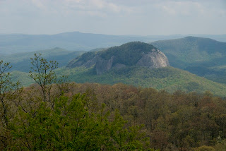
To the south of this site, a pluton formed deep beneath the surface. When it made its way to the surface (or the surface wore down to it) it left this formation known as Looking Glass Rock. Other similar formations are Stone Mountain in Georgia and Stone Mountain in North Carolina.


The geology yields a lot of flat, smooth rock in the area. At one site, a stream flows over this rock, creating a natural sliding board known as Sliding Rock. At the end of the slide you drop into a pool 8 feet deep. Katie would have LOVED this!


About a mile downstream, the water drops over Looking Glass Falls.