
Saturday, December 24, 2011
Thursday, December 22, 2011
Winter Light
I am in New Mexico. Around here, the terrain is high desert. I don't have the magnificent forests and mountains, rivers and waterfalls of my home in the northwest. Instead, I am rewarded by those occasions when I am given light that is just about perfect.
In early December, we had our first snowfall of the season. I got up at dawn and went out. The sunlight of the partially risen sun was kissing the snow sitting on the branches of the desert vegetation.

Later, in fact yesterday, the sky was dark with a passing winter storm. In the late afternoon, a brief hole in the clouds to the west allowed the sun to spotlight part of the far shore.


Then, this morning, I woke to see the first colorful dawn since I got here in late October.


Sweet!
Sunday, November 13, 2011
The Catwalk
The Gila Mountains in western New Mexico are wild and rugged. There are a few trails, and even fewer roads, penetrating this wilderness.
One trail is called The Catwalk. In the late 1800's, a pipeline carrying water was built to facilitate activities such as mining on the western side of the mountain range. The 18" pipe penetrated a slot canyon for 1.1 miles. Those servicing the line walked the top of the 18" pipe to get to the headwaters area. Around the turn of the century, the water pipeline was abandoned. In the 1930's the CCC used the structure to construct a hiking trail. That trail, today, is known as The Catwalk.
It starts as a trail along a stream that cut a slot canyon.

Soon, the trail is suspended above the stream. The rock walls are far too steep to allow a conventional trail.


Did you ever sing in the shower? Imagine singing in this slot canyon! As I was hiking out, there was a group of Scouts hiking in for an overnight. I was enjoying the day, hiking downhill and feeling good, and I am sure they were wondering about the old codger they saw and heard singing on the trail.
All along the trail, there are small waterfalls that treat the eyes and the ears.


Wednesday, October 26, 2011
Drought in the Southwest
We all heard about it, all summer - the lack of rain, dropping water levels...
I did not appreciate it until I got back to my winter resting spot in New Mexico, on the shore of Elephant Butte Lake. First, here is a photo from January, 2010.

While the early morning clouds over the lake hide it and the far skyline to some extent, there is enough there for it to be recognized. The lake was quite broad and forms a substantial impoundment of the waters of the Rio Grande.
Today, the view is quite different. From my usual spot, the lake remains visible to the south. Looking straight across, however...

the lake is gone. To the left of the shot is a paved area that was a parking and prep area for boat launching. Where there was water, there now is a vast flat area of sand, silt, and emerging vegetation. I can't imagine how much water it would take to return the lake to its former level.
Tuesday, October 18, 2011
From The Grand To The Minute
On my way southeast to New Mexico I stopped briefly at a great big hole in the ground - the North Rim of the Grand Canyon.

My destination was Page, AZ, or more specifically, the Upper Antelope Canyon there, another hole in the ground, a few hours from Grand but far from being grand. A walking tour is available to experience this slot canyon. For most of the tour, you do not see the sky and you are in a space tight enough that I had to turn sideways a few times to clear some spots. There is no artificial light. The only light comes from sunlight reflecting off the brown sandstone walls.
Shortly inside the entrance, I looked back and took this shot. The floor of the Canyon can be seen.

In most of the rest of the shots I was looking either straight up, like this one
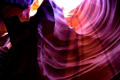
or up and forward like these. (I apologize for this flood of photos without comment, but they tell their own story - they don't need me.)


Friday, October 14, 2011
Zion - Place of Great Walls
From above, Zion National Park seems like an excavation torn into sandstone.

That is exactly what it is. The canyon is formed by the Virgin River excavating the eroded sandstone and washing it downstream.

A tech talk put it into perspective for me. The Lehigh River is a river that I used to paddle a lot. It usually was about 50 to 100 yards wide and ran at summer volumes of about 650 cubic feet per second. The heaviest I saw the Lehigh was at 3000 cubic feet per second. At that flow, it was transformed into a great, powerful wave generator that pushed everything before it, including us paddlers.

The Virgin River runs normally at about 50 cubic feet per second, and in many places is in a channel maybe 20 or 30 feet wide. At flood, however, it has reached 3000 feet per second, and has a fall rate of 75 feet per mile. I would really like to see that - from a distance.
Bryce was a place where most views were from above, looking down into the cluster of hoodoos. Zion is experienced mostly as a narrow valley bordered by the highest sandstone walls in the world.

In the late afternoon, the walls light up with both direct and reflected light.

Dawn, however, was the real jewel of this experience. As the eastern sky began to illuminate a wall, the full moon was settling toward the ridge line. The combination was breathtaking.


Tuesday, October 11, 2011
Bryce Canyon - a helluva place to lose a cow.
Bruce Canyon is most commonly seen from the rim.


Viewpoints along the road open on vistas of striped cliffs, drop-offs and rock spires called hoodoos.


The night after I arrived, the first winter storm struck the area. I stayed toasty in Enterprise as the winds outside brought snow to these high elevations. In the morning, the frosting on the formations made a delightful contrast.

The best way to get a sense of the canyon is to walk one of the many trails that descend from the rim.

The light becomes surreal.


One final shot - the "Poodle" of Bryce Canyon.

Monday, October 3, 2011
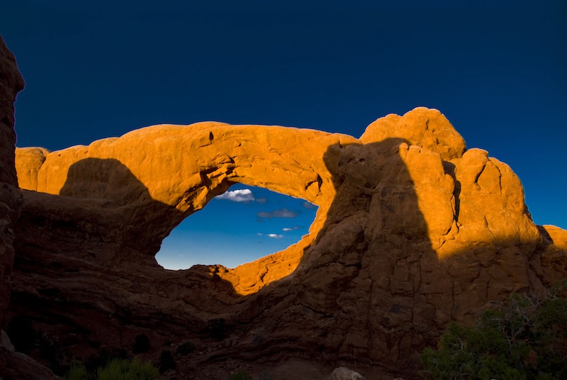
... and Sunset at Arches
I loved the dawn colors at Grand Tetons and Arches, but I must say, capturing sunsets is much more comfortable for me. I scouted around a bit and settled on one area - between South Window Arch and Turret Arch in Arches National Park.
On the way there, the settling sun highlighted some far-off walls. I couldn't resist stopping and getting out the big lens so I could reach out to this scene.

Reaching the parking area for the Windows Arches, I headed up the path, camera on my neck, tripod on my shoulder, and flashlight in my pocket. I settled in the spot I had chosen, then began to second- and third-guess my choice. All shapes and sizes of photographers were walking past me, settling elsewhere.
As the colors began to bloom, I was happy with my location. Good composition and lighting was everywhere. To the south, the fantastic (as in fantasy lands) shapes were calling out to my lens.

To the east, South Window Arch was glowing against the darkening sky.

To the west, God Rays from a setting sun silhouetted the Turret Arch formation.

Oh yeah - a good way to finish my stay at Arches and Canyonlands.
On the way there, the settling sun highlighted some far-off walls. I couldn't resist stopping and getting out the big lens so I could reach out to this scene.

Reaching the parking area for the Windows Arches, I headed up the path, camera on my neck, tripod on my shoulder, and flashlight in my pocket. I settled in the spot I had chosen, then began to second- and third-guess my choice. All shapes and sizes of photographers were walking past me, settling elsewhere.
As the colors began to bloom, I was happy with my location. Good composition and lighting was everywhere. To the south, the fantastic (as in fantasy lands) shapes were calling out to my lens.

To the east, South Window Arch was glowing against the darkening sky.
To the west, God Rays from a setting sun silhouetted the Turret Arch formation.

Oh yeah - a good way to finish my stay at Arches and Canyonlands.
Subscribe to:
Comments (Atom)

