Tuesday, July 23, 2013

Well, THAT didn't work...

Last year, I explored the Black Canyon of the Gunnison - from the rim.  There were few trails down into the Canyon, all to challenging for me.  I was told that there were no trails that traversed the bottom of the Canyon, as it was impassible.

Well, I am back - briefly.  I found a trail that seemed to lead into the Canyon and decided to give it a try.  The trail began where the Cimarron River flows into the Gunnison River.

Across a footbridge, the trail then led downstream among and through boulders on the slope above the river.

The trail became very narrow as it progressed toward increasingly steeper walls.

At one point the trail was about 8" wide, on slightly sloping, loose surface.

The plan here was to move smartly along.  That has two meanings - move briskly, and move intelligently.  Before I entered the narrow, loose section I noticed an area rubbed clear where someone had apparently slipped and slid about 10 feet down the slope.  I wanted to be sure I would not repeat that maneuver, so I planned every footstep, then I made the steps briskly, not waiting to give the stones much of a chance to slide.

The trail dropped toward the river, with less and less space between the wall and the water.

Finally, I got to the trail's end.

Beyond, the vertical walls dropped into the water, leaving no place to walk.  So - I didn't get far into the Black Canyon, but I gave it my best shot.

Crested Butte

Hiking in the Tetons, I was impressed by the profusion of wild flowers.  After I left there, I worked my way south to Crested Butte, CO, called the Wildflower Capital.  Set among the mountains, this would be a really nice area without any flowers.

The flowers were here, though, in abundance.

Sweet


Wednesday, July 17, 2013

On The Road To Colorado

Not with Bob Hope and Bing Crosby, nor with Brian and Stewie... just me, moving along.

After leaving the Tetons I stopped in Riverton for a few days to deal with rig maintenance stuff.  I left there, heading across southwestern Wyoming, for Crested Butte in Colorado.  I stopped on the way at Flaming Gorge in Utah, the place at which I stopped last summer.  Then, I stayed at the Firefighters Memorial campground, with a long view over the region.  This time I stayed at Rim Campground, about 150' from a cliff edge dropping well over 1000' to the waters below.

The daytime view is pretty grand, but the lighting at dusk was much more impressive.


The last rays of the setting sun lit one rock formation before darkness crept in.

The morning sunrise was a great way to begin the day.

This beats the crap out of sleeping in a Walmart or Cracker Barrel parking lot!

On to my next stop, Rifle Gap State Park, then on to my destination.

Thursday, July 11, 2013

Teton Afterimages

The past two months have been spent exploring the Grand Tetons.  I am now moving on, but I felt that I should share those photos that best represent what this experience has been for me.  If you have followed my blog, most of these are reruns, but I think they are worthy of a second look.

When I got to the Tetons, they were still locked in the grip of winter.  While the lakes were beginning to thaw at the edges, they were still mostly ice-covered.  The trails - well, I would have needed snow shoes for most.

It wasn't long, however, before the warmth of the sun transformed the area, turning white to green - and red - and yellow...


The rising sun still lit the prairie grasses as gold rather than green, but that was just fine with me.

Life was springing forth anew all around.


As the spring progressed, I was able to get to higher elevations.  There, the first wildflowers, already faded down lower, were just blooming.


In the campground, early mornings often brought visitors, in this case a bull moose in velvet.

My hikes were getting longer, and higher.  Perhaps the most beautiful, at least to me, were the middle reaches of Cascade Canyon.  I had been there before, but never this far in.


The heat of early summer was rapidly melting the snow on the peaks.  That snowmelt became clear, clean water tearing its way over boulders on its way to the Snake River.

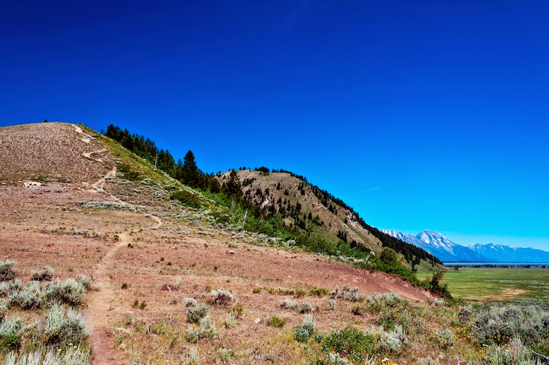
The mental image that I think will stay longest with me is that of the trails, winding their way toward these magnificent peaks, drawing me on with each crest and turn.

The day that I left the Tetons, I spent the night at a roadside pull-off, so I could see the sunset

... and the dawn on the range of peaks I was leaving behind.


One final image - my favorite of the entire stay...  I had spotted a barn that I thought would be a good photo subject with the light of dawn.  So, one morning, I arose early enough to get there before sunrise.  When I got there, I found that about 20 others had had the same idea.  I picked my spot for the composition I wanted, and waited.  When the sun reached the barn, the light, and the scene, were all I had hoped for.

If I see nothing else, this summer will have been a treat.


Thursday, July 4, 2013

Blacktail Butte

Thrice before, I have worked my way up Blacktail Butte.  The first time, I bushwhacked up near the climbing area.  I reached the ridge, several hundred feet above the plain.  The second time, I followed an easier trail on a ridgeline rising from the plain behind the Gros Ventre campground.  That was easier, and I made it about 600' up before retreating.  The third time I was with a friend from the campground.  That time, I made it 800' above the plain (see my posts - "Where Have All The Flowers Gone..." and "Spring Has Sprung In The Tetons").

I figured I was done, but success on other hikes persuaded me to try again.

The summer skies have been pretty spectacularly blue, and the weather has been hot - too hot to hike the shadeless and waterless Blacktail Butte.


On July 2, I decided to go for it, hiking mid-morning before the heat settles in rather than my usual afternoon hiking time.  The start was just as impressive as before.  That trail is where I was headed.

The sky was... incredibly blue.  And dry - the trail underfoot was powdery.

I got to the 800' point and took a rest at a spot of shade while I re-assessed.

My rest spot was fringed by an area with trees.  The border between those trees and the prairie grasses that cover most of the Butte abounded with flowers, even more than the last time I was up here.

I moved on.  I added another 200' of elevation, coming to an area where the flowers were fewer, different varieties, and of more intense coloration.


I reached a high valley area.  The trail continued up a grassy slope.  My GPS told me that the high point was at least another 500' of elevation, so I turned around.  Working my way up that valley, I was too hot and too focused on self assessment to really notice my surroundings.  Coming down, I realized that the trail in the bottom of that high valley was fringed with a delightful assortment of color, a mix of wildflowers of all kinds. (Can you see the trail winding between those blooms?)

The descent was unremarkable, except that the dry conditions made the trail crumbly and the footing less certain than on my prior climbs.  My hiking poles made it work.  I returned to camp, having done a hike over 2 miles long and 1000' high.  I'm satisfied with that.