
Wednesday, December 22, 2010
Monday, December 20, 2010
Las Cruces for the Holidays
I am now about 15 miles north of Las Cruces, and will be here for the holidays. From my campsite, I can see the very remarkable, very jagged peaks that rise about 10 miles to the east of Las Cruces. Friday evening, the sun lit them nicely for me.

Yesterday I took a long drive, dropping briefly into Texas, then up to Alamogordo for a late lunch. I then went to White Sands, seeking some shots near to sunset. I was disappointed because I could not find much to use the light that I had and capture the vast whiteness of the dunes. I did have a nice blue sky at first, which I liked in contrast to my shots from a month ago.

I saw the sun lighting a clump of grass. That light was closer to what I was hoping to find.

Moments later, the sun was setting. The color was obscured by the dunes and far peaks, and was bland at first, a pastel yellow with some pink. The sky was not yet rich, it became so later. This is what I saw as I was leaving and had a better view to the west. (OK, I admit it - I couldn't resist slipping in another sunset.)
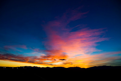
Everyone that I saw during the early part of the sunset was looking to the west. Me? I was looking east at what the light was doing to the mountains near Alamogordo.

Wednesday, December 15, 2010
Play It Again, Sam
Another great sunset at Elephant Butte. I was speaking with my brother and I mentioned that the sky was a dull grey-orange, except for one tiny cloud that was a fiery orange, too small for photographing. Minutes later, clouds to the northeast lit up like they contained Thor's forge.

I grabbed my camera and went out, getting the above shot. As I turned around, the sky to the south, then the southwest lit up.

 I really love sunsets!

I grabbed my camera and went out, getting the above shot. As I turned around, the sky to the south, then the southwest lit up.


Saturday, December 11, 2010
Another Elephant Butte Sunset
Like snowflakes, no two sunsets are the same. This one started with some interesting light on one of the far mountains.

It grew into some very nice colors which, unfortunately, were right over the campground, putting shelters and RV's in the foreground.

I cropped them out as much as I could, then it occurred to me - when faced with a detracting foreground, change it!
 Yeah - THAT works!

It grew into some very nice colors which, unfortunately, were right over the campground, putting shelters and RV's in the foreground.

I cropped them out as much as I could, then it occurred to me - when faced with a detracting foreground, change it!

Wednesday, November 24, 2010
White Sands National Monument
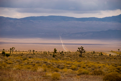
East of Las Cruces, surrounded by mountains, is a vast basin named White Sands. Much of it is classic southern desert, with scrub vegetation and a predominant color of tan. In the center is an area of drifts of white sand, which has been designated a National Monument.
I had mixed feelings about going there. I usually am not much into desolation, being much more attracted to the mountain rivers, lakes, streams and forest that fill my eyes with greens and blues. Yet, being only 60 miles away, I decided to drive to White Sands.
At first, I saw only white dunes, with little to attract my eye. I then started to see the interplay of light on the shapes and the surface textures, and began to use my camera.


As I shot, I became more and more caught up in the textures.


The dunes not only look like snow drifts, they offer similar opportunities for fun. Many of the dunes were capped by sledders using plastic saucers to slide down the dunes.

 I may go back later in the afternoon. I bet a sunset would add some really interesting color.
I had mixed feelings about going there. I usually am not much into desolation, being much more attracted to the mountain rivers, lakes, streams and forest that fill my eyes with greens and blues. Yet, being only 60 miles away, I decided to drive to White Sands.
At first, I saw only white dunes, with little to attract my eye. I then started to see the interplay of light on the shapes and the surface textures, and began to use my camera.


As I shot, I became more and more caught up in the textures.


The dunes not only look like snow drifts, they offer similar opportunities for fun. Many of the dunes were capped by sledders using plastic saucers to slide down the dunes.


What a Way to Wake Up!
I was in bed early one morning 5 days ago. Looking up through the window, I saw some clouds with color. Color overhead at dawn is somewhat unusual, so I sat up. One glance out the rear window, and I grabbed my clothes, dressed, and ran outside with my camera. This is what I saw.

I took a few shots, then came back inside. I short time later, the color was gone, but the patterns on the lake were kind of cool.

Such shows are rare, but continue to delight.

I took a few shots, then came back inside. I short time later, the color was gone, but the patterns on the lake were kind of cool.

Such shows are rare, but continue to delight.
Thursday, November 18, 2010
Elephants and Tarantulas
I am at Elephant Butte State Park. How did it get its name? Well... (click to see the labels)

A few days ago, I was driving a back road, doing around 60. On the pavement in front of me, I saw something moving. I had enough of a view of it to stop before reaching it. I grabbed my camera and jumped out to take a photo, getting to it just as it entered the grass fringe at the edge of the road.
 Pretty cool!

A few days ago, I was driving a back road, doing around 60. On the pavement in front of me, I saw something moving. I had enough of a view of it to stop before reaching it. I grabbed my camera and jumped out to take a photo, getting to it just as it entered the grass fringe at the edge of the road.

Wednesday, November 10, 2010
Elephant Butte Sky
This shot was taken by the back bumper of my RV two nights ago. I am at Elephant Butte Lake State Park. The lake is to the east. The campground to the west of me makes most sunsets not very appealing for photography. There is usually someone's RV, or the roofs of the structures over the picnic tables that spoil the shot. With the sun setting in the west, there usually is not much color to the east. but this was a real exception.


Saturday, November 6, 2010
Oregon wanderings - Wowzers!
Just for curiosity, I continued with the mapping I had done in the past, marking out where In Oregon I have been. The map is pretty interesting, more so if you were to compare it to mountains in the state.
 Essentially, the Cascades are pretty well covered. The Wallowa's and Hell's Canyon could take a bit more attention. Everything else is either flatlands or mountainous desert.

Autumn in New Mexico
In an earlier post I commented on the golden colors of some of the trees. They are in the higher elevations of New Mexico too.

I spent a week camped in Cimarron Canyon. The campground was next to a trout stream. Downstream about 1/4 mile was a beaver pond.

Those of you who were Boy Scouts probably heard of Philmont Scout Reservation. I did, and in my youth dreamed of going there. It is renowned for wilderness, scenery and a superb nature experience. In the photo below, that is Philmont in the background. Cimarron Canyon State Park borders Philmont. I finally got here!

Thursday, October 28, 2010
East into New Mexico
I left the Sierras behind and crossed into Nevada. Things there tend to be kinda straight and flat...
Shortly before entering New Mexico, Arizona presented me with the vista of a developing storm. Awesome clouds!

That night, staying at Bluewater Lake in western New Mexico, I was surrounded with an impressive thunder and lightning storm, complete with hail. Knowing Andy's experience of having his RV struck by lightning, I made sure I was unplugged, then sat in Enterprise and rode it out. It seemed... bigger... than the thunderstorms I was used to in the east.
Monday, October 18, 2010
Across the Sierras
After a nice visit with Dawn and Dylan, I left Placerville (Sutters Mill), heading toward Albuquerque. The first leg of my journey took me up and over the Sierras.
It was a grey, rainy day, which was good, because I pulled into my overnight stop at Lee Vining, on the eastern edge of Yosemite, at about 4:00. Had it been a clear, sunny day I think I would not have gotten there until after dark. The ride was spectacular! The higher elevations were lined with trees filled with luminous yellow-gold leaves. Safe places for me to stop were few, so I mostly kept rolling. Had the sun been out, I am sure I would have unhooked Galileo and been off exploring with my camera.

I got to Lee Vining and parked. As I was setting up Enterprise for the night, the sun peeked out long enough to give me a rainbow over Mono Lake. Niiiice.

Tuesday, October 12, 2010
Lassen
It would be both ignorant and arrogant to say that I have seen Lassen Volcanic National Park. I have driven the road through the park, which exposes me to perhaps 1% of that place. To see more, I would have had to hike some of the many trails that weave up, down, and around this marvelous place.
For me, this park was mostly about water. At lower elevations, the road is bracketed by beautiful forest. The valleys are lined along the bottom by clear mountain streams bubbling over the rocks.

At higher elevations, mountain meadows appear. These meadows have slow, clear streams winding through them. Erosion of the deeper slopes and deposition when the waters slowed formed these tranquil flats.

The really high mountain lakes are clear basins of water reflecting the blue mountain sky, bordered by volcanic rocks and peaks.

Near the high point of the road, a large boulder (I estimate about 12 feet high) is seen. Thrown there from a volcanic eruption many miles away, it gives a tiny sense of the raw power contained in a stratovolcano.

That power is not gone, just resting. In the southwestern corner of the park, the road passes between mud pots and fumaroles, each bubbling with sulphurous steam.


Thursday, October 7, 2010
Creating the "Impossible" Photo
I am at McArthur-Burney Falls in Northern California. The trail to the base of the falls is closed for maintenance, so I can't get a good perspective. From the remaining overlook, I am shooting down at the falls (not my favorite perspective). The face of the falls is wide, and is bracketed by trees so that one can only see a part of the falls from any one viewpoint. To deal with that, I took three photos, moving my tripod about 15 feet between each shot. I then photomerged the three shots to get a composite that shows almost all of the falls as one image, a view that cannot be seen in real life. I am happy with the result.
 These falls are unusual. One mile upstream, there is no surface flow at all. At the falls, the flow rate is 100,000,000 gallons per day, slightly more than Blue Spring and Alley Spring in Missouri, which flow at 87,000,000 per day. Those are set in karst topography and flow from limestone. Here, the surrounding landscape is volcanic in origin.
The falls flow in two layers - a primary surface flow that drops over the edge in two main streams,

and an underground river that breaks into the air in a horizontal plane separating two rock types. The result is a thin curtan of tiny waterfalls spread over a wide front.

Pretty cool!

The falls flow in two layers - a primary surface flow that drops over the edge in two main streams,

and an underground river that breaks into the air in a horizontal plane separating two rock types. The result is a thin curtan of tiny waterfalls spread over a wide front.

Pretty cool!
Sunday, October 3, 2010
Shasta
Lake Siskiyou, where I am camped, is near Mt. Shasta. Shasta is an immense stratovolcano. Click on the image to see the town of Mt. Shasta, at the foot of the mountain.

I drove up Shasta on an access road, about 1/3 of the way to the top to get this view. Even from only 1/3 of the way up, I was well above most other peaks in the region.

In my campground, there is a herd of two does and three fawns, one still wearing his spots.

They seem very comfortable here, and most of the feeding seems to be very natural - twigs and leaves, with some pawing for acorns.

Tomorrow, I leave here for McArthur-Burney Falls.

Embarkation
After six months in Oregon, making it my home, it is time to start heading south. On a misty morning, I say goodbye to South Beach State Park in Newport.

Entering northern California, I stayed for a few days at Siskiyou Lake. To the south is a remarkable collection of granite outcrops. The granite in Yosemite and in Maine is a medium gray. The granite at Castle Crags is a very light gray, almost a white appearance.
Viewed from about 10 miles away, the Castle Crags form a jagged pale gray eruption from the smoother forest surrounding it.


In my campground, I looked out my window and saw...

As a rule, I'm not a fan of this kind of human-wild critter interaction. I prefer to see the animals in a more natural way, with minimal effect from man. There was something really neat though about seeing this woman, who has been feeding this deer for 2 years, interacting with an animal that other than its calmness in being in the campground, appeared to be a healthy, normal buck.
Subscribe to:
Posts (Atom)

