The upper McKenzie drops over three lava flows from Belknap Crater, two from 3000 years ago and one from 1500 years ago. The result is a beautiful and clean river and three waterfalls, Sahalie Falls, Koosah Falls and Tamolitch Falls.
The upper or first is Sahalie Falls. It drops 120 feet in two parallel cascades.
The middle drop is Koosah Falls. This one drops 90 feet in a series of steps and slopes. It was beyond my safety zone to get a good angle to photograph it. (Oops - I learned from a comment that this is not Koosah, but is simply a small cascade.)
The third waterfall is Tamolitch. (Oops - this is actually Koosah. Tamolitch would have been well beyond my hiking range. Thank you, commenter, for the help.)
Between these drops, the McKenzie River romps playfully, clear and cold.
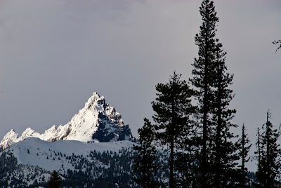
At my campsite when I started out, the day was clear, sunny and about 80 degrees. Above the falls area, in the headwaters of the McKenzie is a mountain named 3 Fingers Jack.
It is May 8th, and many of the roads up there are still closed by snow. I actually ran into a snow flurry there. As Yakoff Smirnoff says, "Whadda Country!"


1 comment:
Nice pictures! Just wanted to let you know the second picture is not Koosah Falls, just a series of cascades below Sahalie Falls. The third picture is of Koosah Falls, not Tamolitch Falls. Tamolitch Falls doesn't exist anymore, the McKenzie River is diverted somewhere below Koosah Falls for hydroelectric purposes. Here's an article about how rare it is to see water going over at Tamolitch.
http://www.kval.com/younews/22696999.html
And here are some pictures of Tamolitch.
http://www.pbase.com/greglief/tamolitch_pool
Post a Comment